
New Mac Electric Cooperative is governed by a nine-member Board of Directors, with one director elected from each district. Find your district below and learn how our cooperative is represented across southwest Missouri.
New Mac Electric Cooperative is divided into nine districts. Each district is represented by one member elected to serve on the Board of Directors. These districts help ensure members across our service area have local representation and a voice in the cooperative.
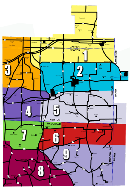
DISTRICT BOUNDARIES
Click on the boundary below to see the detailed legal description.
DISTRICT NO. 1. Commencing at the intersection of U.S. Highway #71 and Newton County “V” Highway, said point being the Southeast corner of Section 16, Township 26, Range 32, thence North along U.S. Highway #71 to the Newton-Jasper County line, thence East along the said county line to the Lawrence County line, thence South along the Newton-Lawrence County line to the Southeast corner of Section 2, Township 26, Range 29 (being the junction of said county line with Newton County Highway “J”), thence West along County “J” and “V” to place of beginning. Together with that portion of the Cooperative territory in Jasper County, Missouri, lying due North of the above described district as extended, and that portion of the Cooperative territory in Lawrence County, Missouri, lying due East of the above described district as extended.
DISTRICT NO. 2. Commencing at the Southeast corner of Section 16, Township 25, Range 32, thence due North to the junction of U.S. Highway #71 and Newton County Highway “V”, following Newton County Highway “V” North from junction, thence East along Highway “V” and “J” to the Newton-Lawrence County line, thence South to the Southeast corner of Section 14, Township 25, Range 29, thence West along section lines to the junction of Missouri Highway #86, thence continuing West along said Highway #86 to the place of beginning, together with all that portion of the Cooperative territory in Lawrence County lying due East of the above described district as extended.
DISTRICT NO. 3. All that part of the Cooperative territory described as commencing at the Southeast corner of Section 16, Township 25, Range 32, and running West along the State Highway #86 to Racine, thence continuing due West along section lines to the Oklahoma State line, thence North along the State line to the Newton-Jasper County Line, thence East along the Newton-Jasper County line to U.S. Highway #71, thence South along U.S. Highway #71, to the junction of U.S. Highway #71 and County Highway “V”, thence due South to place of beginning, together with that portion of the Cooperative territory in Jasper County, Missouri, lying North and West of the herein described district as extended.
DISTRICT NO. 4. Starting at the Oklahoma State line at the South line of Section 32, Township 24, Range 34, thence East along the Newton-McDonald County line to the Southeast corner of Section 36, Township 24, Range 33, thence North along section lines to the intersection with U.S. Highway #60, thence East along U.S. Highway #60 to the intersection of U.S. Highway #60 and U.S. Highway #71, thence North along U.S. Highway #71 to intersection with Missouri Highway #86, thence West along said Highway #86 to Racine, thence continuing due West along section lines to the Oklahoma State Line, thence South along State line to place of beginning.
DISTRICT NO. 5. Commencing on the Newton-McDonald County line at the Southeast corner of Section 36, Township 24, Range 33, thence North along section lines to the intersection of U.S. Highway #60, thence East along U.S. Highway #60, to its intersection with U.S. Highway #71, thence North along U.S. Highway #71 to its intersection with Missouri State Highway #86, thence East along said Highway #86 to Newtonia, thence continuing due East along section lines to the Newton-Barry County Line, thence South along said county lines to the Newton-McDonald County line, thence West along the Newton-McDonald County line to the place of beginning. Together with that portion of the Cooperative territory in Barry County, Missouri, lying due East of the above described district as extended.
DISTRICT NO. 6. Commencing on the Newton-McDonald County line at the Northeast corner of Section 1, Township 23, Range 32, McDonald County, Missouri, thence South to the Southeast corner of Section 12, Township 23, Range 32, thence due East to U.S. Highway #71, thence South on U.S. #71 to the point where Missouri Highway #76 leaves U.S. Highway #71 in an easterly direction, thence East along Missouri Highway #76 to the point where Highway #76 intersects with the North line of Section 4, Township 22, Range 31, thence continuing due East along section lines to the Barry County line, thence North along the county line to the Newton-McDonald County line, thence due West along said county lines to place of beginning. Together with that portion of the Cooperative territory in Barry County lying due East of the above described district as extended.
DISTRICT NO. 7. Commencing on the Newton-McDonald County line at the Northeast corner of Section 1, Township 23, Range 32, McDonald County, Missouri, thence West along the Newton-McDonald County line to the Oklahoma State line, thence South along State line to the Northwest corner of Section 33, Township 23, Range 34, thence East along the section line to Northeast corner of Section 34, Township 23, Range 34, thence South to Missouri Highway #76, thence East along Highway #76 to the Intersection of U.S. Highway #71, thence North along Highway 71 to the North line of Section 18, Township 23, Range 32, thence East long section lines to the Southeast corner of Section 12, Township 23, Range 32, thence North to place of beginning.
DISTRICT NO. 8. Commencing at the Northwest corner of Section 33, Township 23, Range 34, thence East to the Northeast corner of Section 34, Township 23, Range 34, thence South to State Highway #76, thence East on said Highway #76 to its junction with U.S. Highway #71, thence South on U.S. Highway #71 to the Arkansas State line, thence west along the Arkansas State line to the Oklahoma-Missouri State line, thence North along the Oklahoma-Missouri State line to place of beginning.
DISTRICT NO. 9. Commencing on the McDonald-Barry County line at the Northeast corner of Section 4, Township 22, Range 29, thence due West along section lines to the junction of Missouri State Highway #76, thence continuing West along said Highway #76 to its junction with U.S. Highway #71, thence South along U.S. #71 to the South boundary line of McDonald County (being the Arkansas State line), thence East along said County line to Barry County Line, thence North along the McDonald-Barry County line to place of beginning, together with that portion of the Cooperative territory lying due East of the above described district as extended.
Current Board Representation
District 1 - Bruce Youngblood - Term: 2023-2026
District 2 - Tim Short - Term: 2025-2028
District 3 - Richard Leavens - Term: 2023-2026
District 4 - Beryle Kennedy - Term: 2024-2027
District 5 - Billy P. White - Term: 2024-2027
District 6 - Paul Sprenkle - Term: 2023-2026
District 7 - Dewey Allgood - Term: 2025-2028
District 8 - Jason Ruddick - Term: 2025-2028
District 9 - Jamey Cope - Term: 2024-2027